


aaaa

parastat
User
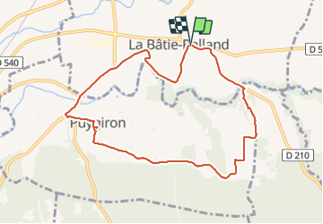

Length
9.3 km

Max alt
206 m

Uphill gradient
127 m
Km-Effort
11 km

Min alt
133 m

Downhill gradient
121 m
Boucle
Yes
Creation date :
2021-11-07 12:57:36.029
Updated on :
2021-11-07 15:27:59.676
2h09
Difficulty : Medium

FREE GPS app for hiking
 SityTrail
IGN / Geographical institutes
SityTrail Plus
The world is yours!
About
Trail Walking of 9.3 km to be discovered at Auvergne-Rhône-Alpes, Drôme, La Bâtie-Rolland. This trail is proposed by parastat.
Description
marche
Positioning
Country:
France
Region :
Auvergne-Rhône-Alpes
Department/Province :
Drôme
Municipality :
La Bâtie-Rolland
Location:
Unknown
Start:(Dec)
Start:(UTM)
648216 ; 4935042 (31T) N.
Comments